 |

The
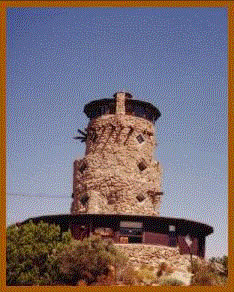
Desert Tower |
|
On clear, desert nights the Desert Tower's lights hang
in the western sky like stars. Perhaps it is fitting
that the lighthouse-like tower, located in In-ko-pah
on the western edge of Imperial County, should stand
sentry 3,000 feet above the Imperial Valley. Nestled
in a forest of sheltering boulders, the granite tower
stands where a way station once offered solace to weary
travelers.
Before cars and air conditioners, only the hardiest
dared journey East of here into the torrid wilderness
below, where summer temperatures of more than 100 degrees
could bring quick death to the unlucky or unprepared.
It was during 1910-1920 that Bert Vaughn, originally
from West Virginia, came to Jacumba. With his financial
ties in both San Diego and El Centro, Vaughn was conscious
of the possibilities on both sides of the mountains.
Further, his years as a real estate developer pointed
to the fact that the Jacumba Valley was the logical spot
on the San Diego-Imperial routes for a much needed town.
In the early 1920's, Vaughn, who at the time owned the
town of Jacumba, decided to build the 70-foot tower as
a tribute to the days when it took a month to travel
from San Diego to Yuma, AZ. He laid the first course
of rocks in 1922, and sealed them in place with hand
mixed cement. The base was built of solid rock, and so
well anchored that the sixty years of ferocious winds
and blasting by crews as they changed the highway to
a freeway in the late 1960's seem not to have moved it
at all. Water was often in short supply and buckets hauled
to the construction area when the springs went dry. By
late 1923, the base of the tower was well established
and the walls began to rise. The tower was not completed
until 1928.
The tower was abandoned for many years until Dennis A.
Newman, a fighter pilot who flew for Britain's Royal
Air Force during World War II, bought it. He restored
the tower to its former granite glory, and built a shop
around its base. An antique store occupies the shop and
it is still open, selling old guns, swords, dolls and
lamps.
Today travelers from all over the world visit the tower
for its great view. Many climb the 57 steps to the hurricane
deck at the top of the tower, from where the Valley and
Mexico appear serene, even on blustery winter days.
Photographs grace the four-foot thick walls inside the
tower, giving visitors a local history lesson. The black-and-white
images of those connected with building the tower are
frozen in time, including pictures of the weather-beaten
workers who built the tower for a mere $3.00 a day.
Just outside the tower is Boulder Park. Here you can
see huge granite snakes, lizards, and a human skull that
were chiseled from boulders during the Great Depression.
To get to the tower take the In-Ko-Pah exit from Interstate
8, and travel east along the northern side of the highway
for about half a mile. The tower is open from about 8:30
a.m. to 5:00 p.m. every day of the year. Visitors over
12 years of age pay $2.00 to see the tower's hurricane
deck and Boulder Park.
Story thanks to http://www.imperialcounty.com/index.html |
 |

Old
Plank Road |
|
My
understanding is that Gordon's well was drilled by
the county of Imperial to support travelers along the
old Plank Road. From what I have read, there were two
or three wells drilled, Gordon's, Greys and the "county
well". Its possible that the "county well" is
actually Gordon's or Grey's but I am not certain about
that. I have simply seen a reference to a county well
in the dunes.
I consulted some of my historic maps. I have an Automobile Club (AAA) map dating
to 1916 that shows a well located roughly where Gordon's should be, and I came
across a photo, probably taken in the late 1930's, based on the style of cars,
that simply says "Oasis in the Sand Hills on Highway 80 Imperial County,
Cal." It has two cars parked next to what appears to be a well with Tamarisk
trees growing beside it.
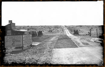
There is also a photo that was produced by a local photographer named Leo Hetzel
about 1915. Attached is a scanned in version of the photo. A closer look at the
sign on top of the building indicated that the signs says "Greys Well Service
Station." But based on where the station appears to be located in relationship
to the dunes, this might actually be where the modern maps place Gordon's well.
Its not unusual to have these kinds of discrepancies. - Margaret Hangan |
 |
The
basic story is that Sue Gordon was my
great Aunt and she and her Husband owned and ran the
Gordons Well Oasis. I
understand there may be some pictures of Sue riding her
horse in the dunes
and old man Gordon had a stripped down car (frame, seats
and motor) that he
would dune in. My
grandmother used to dune, my dad still does as well as
my kids 4
generations of duners!
Thanks!
Troy J. Leezy |
| |
|


